Concept of the project “Assessment and reduction of landslide hazard risks in populated areas of built-up territories and agricultural lands”
Pilot areas:
– Uzgen district of the Osh region;
– Suzak district of the Jalal-Abad region;
– Aksy district of the Jalal-Abad region;
Stages of implementation:
Stage 1 – Study and Evaluation;
Stage 2 – Practical measures;
Implementation period:
Within 2 years, 2019-2020
Executing Agency:
Ministry of Emergency Situations of the Kyrgyz Republic. (Department of monitoring and forecasting emergencies);
Member organizations:
– Ministry of Agriculture, Food Industry and Land Reclamation of the Kyrgyz Republic (Pasture Department);
– State Committee of Industry, Energy and Bosom Use of the Kyrgyz Republic (State Enterprise “Kyrgyz Hydrogeological Service”);
– State Agency of Architecture and Construction;
– National Academy of Sciences of the Kyrgyz Republic (SIC “Geopribor”);
– Center for Earth Research, Potsdam, Germany (CAIAG);
– Tian-Shan Geological Society
Requisites:
Address: Kyrgyz Republic, Bishkek, Osmonkul St. 128;
Tel: +(996 312) 68-03-94, 43-91-14,
E-mail: depmon@mail.ru
Contacts:
Department of Monitoring, Forecasting Emergencies of the Ministry of Emergency Situations;
Director Aytaliev Anarkul Maksutovich
General situation:
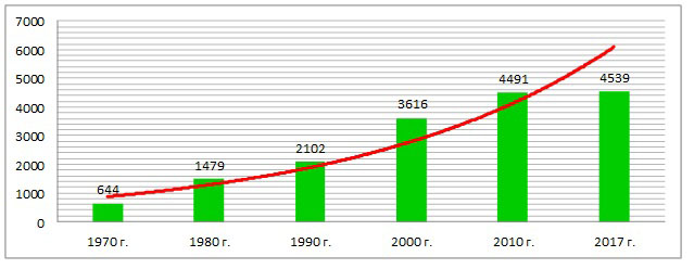
There are about 5,000 modern landslides in Kyrgyzstan. Their number increases annually due to the activation of modern geological and climatic processes. An important role in the formation of landslides is played by anthropogenic factors.
Landslides on the territory of Kyrgyzstan lead to the destruction of houses and infrastructure of settlements. Landslides that occur in mountain gorges can block river beds and form breakthroughs — dangerous lakes, which, during a catastrophic breakthrough, generate mudslides and affect vast areas.
In a complex mountainous terrain, synergistic natural disasters form on the territory of Kyrgyzstan when landslides occur. The nature of such disasters in mountainous areas is reflected in the fact that a landslide causes a number of other dangerous phenomena.
Long-term observations show that a large number of landslides are formed in high-water years (such were 1969, 1978-79, 1988, 1994, 1998, 2002, 2003, 2004). Large landslides, which are formed under the influence of groundwater, occur in low-water years, regardless of the period of the year. The greatest activation of landslides occurs in the spring during precipitation and the period of melting of snow.
The number of landslides and the area of landslide damage increases annually. The main reason is the activation of exogenous-geological processes and anthropogenic factors. Millions of cubic meters of rock are involved in the movement.
The main threat to the life and health of the population is the danger of sudden destruction and burial of houses, public buildings, life support facilities, hazardous facilities, engineering structures, roads, canals, power lines, etc. In 2000-2017, 136 people died under landslides. In 2017, 34 people died.
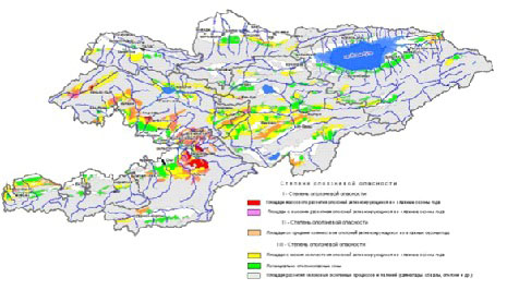
The total area of lands affected by landslide processes is about 7.5% of the territory of the republic. In total, about 600 settlements (1109 dangerous areas) are located in the landslide-hazardous zones. In potentially dangerous areas there are up to 10 thousand houses and objects, the danger for which will increase.
Analysis of the situation:
The process of activation and formation of landslides increases every year due to modern geodynamic movements, earthquakes, rising groundwater levels, abnormal rainfall, and also as a result of technical and human activities (elimination of vegetation on slopes, flooding, artificial pruning of the slopes, construction of structures), leading to a violation of the natural stability of slopes.
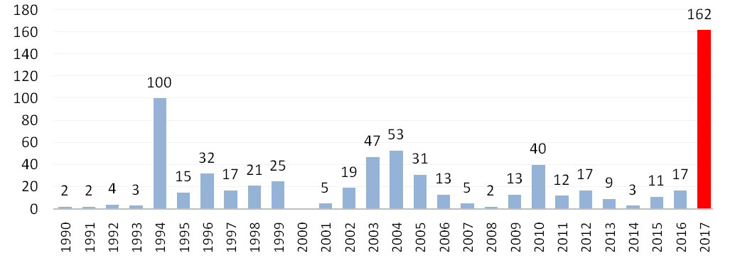
After a long period of relative calmness in the formation of landslide processes in the territory of Kyrgyzstan, in 2017 there was a new regular period of mass activation of landslides. Over the past 30 years, the massive occurrence of landslides in the south of Kyrgyzstan was noted in 1993-1994 and 2003-2005. In 2017, in the southern region of the country, 162 landslides happened, with a total volume of 82.8 million m³, of which 69 landslides created emergency situations that caused loss of life (34 people) and material damage (6.7 billion soms), creating a threat to the safe life of the local population. In 2017, the number of landslides was equal to an average amount that happens over 9 years, or 8 times more than the average amount over 26 years.
Specialists of the Department for Monitoring Hazardous Natural Processes of the Ministry of Emergency Situations of the Kyrgyz Republic conduct regular visual surveys of sites with the development of new landslides. These surveys are carried out without a detailed study of landslide slopes and are only a method of early warning of potential landslide danger and the relocation of people from dangerous areas.
Landslide threat can only be detected on slopes with clear signs of landslide hazard, which appear on the surface in the form of cracks, subsidence of soil, etc.
Currently, only a general approach to landslide hazard assessment has been developed in Kyrgyzstan. Ensuring the safety of the population living in areas of landslide formation requires an integrated approach to study them. As international experience shows, a more accurate forecast of landslide hazard can be determined by the results of scientific research, engineering geological surveys and field observations using special equipment.
Landslide processes are of extreme concern to the Government of the Kyrgyz Republic, local governments and the population, since the population and infrastructure are concentrated in areas of occurrence of landslides.
Since 2018, the State Committee for Industry, Energy and Subsoil Use of the Kyrgyz Republic resumed the work on the study of landslides, which was suspended about 20 years ago due to the ending of the activities of the landslide squad as part of the Osh Hydrogeological Service. But financial opportunities do not allow organizations that study landslides to carry out all the necessary complex of works on monitoring and forecasting landslides and taking appropriate measures to protect the population, territories and reduce landslide risk.
At present, there are no developments to determine safe places for planning new settlements or expanding existing ones. Territories are not regionalized by landslide risk for residence or other land use.
Allocation of land for the construction of residential buildings and communications is carried out without taking into account landslide risks and often leads to an increased danger to the vital activity of the population.
The Government of the Kyrgyz Republic adopted the “Program for the Development of Master Plans for the Settlements of the Kyrgyz Republic for 2018–2025” (PPKR No. 490 of 17.08.2017), which provides for the development of master plans for 1821 settlements.
The program requires that master plans for the construction and development of human settlements to be developed taking into account landslide and other dangerous geological and man-made processes.
Objective of the project:
The main objective of the project is the assessment and regionalization of territories according to the degree of landslide hazard, as well as the assessment of lands for living and agricultural work. The regionalization of landslide danger will bring tangible benefits to the policy of building settlements and ensuring the safety of the population and territories.
The anticipated work will provide an opportunity for warning and risk assessment in advance, monitoring their development and informing about the threat of possible emergency situations.
Project goals.
- Study and assessment of landslide processes in the territory of the Kyrgyz Republic;
- Regionalization of the territory according to the degree of landslide hazard;
- Mapping with the development of landslide processes;
- Prediction of landslide hazard, development of recommendations to reduce the risk of landslides to ensure the safety of the population;
- Development of methods for strengthening landslide slopes;
- Development of a landslide passport and the creation of a landslide cadaster;
- The provision of these materials to local authorities, state administrations, the State Agency of Architecture, Construction and Housing and Communal Services under the CAP, as well as organizations involved in the development of master plans for settlements;
- Creation of a regional landslide center;
- Grounding and establishment of a continuous regional monitoring system at representative (pilot) landslide sites. Introduction of modern technical methods for monitoring landslides and data processing to obtain indicators of landslide-forming factors for the purpose of further risk assessment and reliable time forecasts of early warning
Expected results:
– Creating a database of landslide processes, taking into account the areas of potential new construction and use of agricultural land;
– Improving the accuracy of the forecast landslide hazard for the development of protective measures and early warning;
– Reduction of damage and loss of life from landslide processes;
– Organizations, departments and civil society will have access to information on landslide hazard.
– Reclamation of destroyed lands after landslides for the vital activity of the local community.
– Development of the Concept of landslide safety in the Kyrgyz Republic for 2020-2030.
– Creation of a system of automatic comprehensive monitoring and scientifically based forecast of landslide hazard
The project results will be the basis for a long-term national project in 2020-2030.
The project results will create conditions for the practical implementation of the “Concept of comprehensive protection of the population and the territory of the Kyrgyz Republic from emergencies for 2018–2030”, “Programs for the development of master plans for settlements of the Kyrgyz Republic for 2018–2025, taking into account landslide and other hazardous processes”. Also, the results of this project will form the basis for the development and implementation of a large-scale National Project of the Government of the Kyrgyz Republic to solve problems related to landslide processes, which can be implemented with the support of international financial organizations, development partners, as well as in the framework of public-private partnership with local farmers, private organizations and land owners and objects.
The future National Project may include practical activities:
1) Reclamation of lands destroyed as a result of landslides in order to restore them quickly for further use. Subsequent provision of these lands to the Project partners (local farmers, private organizations and the public) for their further use for agricultural and other purposes;
2) Carrying out activities with the use of possible options for stabilization and unloading of active landslides and the subsequent rehabilitation of lands damaged by landslide processes.
3) Creation of a monitoring systems on landslide-hazardous slopes with the participation of the Landslide Service of the State Committee for Industry, Energy and Subsoil Use of the Kyrgyz Republic.
