+996(776) 991 663 info@geotianshan.org РУС
logo Tian-Shan Geological Society
  • IGCP 727
    • Project news 727
  • Home
  • About us
    • Membership
    • Statutes & Bylaws TSGS
    • Benefits of IUGS Membership
    • Our mission
  • Projects
  • Expeditions
  • News
  • Contacts
logo
РУС
  • IGCP 727
    • Project news 727
  • Home
  • About us
    • Membership
    • Statutes & Bylaws TSGS
    • Benefits of IUGS Membership
    • Our mission
  • Projects
  • Expeditions
  • News
  • Contacts

Geological Tours

What could be better than field practice with your camera

/ Geological Tours

Central Asia is an ideal area for geotourism. The mountains of Central Asia are a magnificent natural laboratory for visual knowledge of the geological history of the Earth. The Tian-Shan and Pamir mountains represent a variety of unique landscapes, stratotype sections, geological processes, mineralogy and paleontology. Here you can observe how modern geological processes proceed. These geoprocesses form a diverse relief. The unique geology of the Tian- Shan helps us to make any reconstruction of geological history over millions of years. Almost the entire geological evolution of the Earth is represented in Central Asia. It is a region with a diverse geological heritage and a great opportunity for research, education and geotourism.

Geological tour – All Western Tian-Shan. Kyrgyzstan

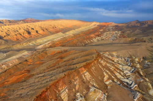
Пять стран Центральной Азии занимают крупнейшую горную систему - Тянь-Шань. Китай и Кыргызстан, занимают более 70 % всей территории Тянь-Шаня, поделив между собой западную и восточную части этой горной системы. Краевые части Тянь-Шаня достались Узбекистану, Казахстану и Таджикистану. Тянь-Шань – это крупнейший аккумулятор влаги в Центральной Азии. Не трудно представить, что если бы не было этих высоких гор, то вся территория Центральной Азии превратилась бы в песчаную пустыню. Поэтому, Тянь-Шань и его ледники выполняют важную функцию как крупнейшая область аккумулятора влаги. Тянь-Шань это крупнейшая в мире геологическая лаборатория, музей под открытым небом, где представлена вся история планеты Земля. Программа геотура может быть адаптирована для преподавателей геологии, географии, а также для школьников, студентов, молодых учёных, любителей дикой природы и приключений. Данную программу можно изменить в зависимости от вашего предпочтения, возраста участников, сезона и времени на путешествие. В течение всей программы геотуристы передвигаются на комфортном автомобиле, ночуют в отелях и гостевых домах. В некоторых диких геолокациях участникам предлагается остановиться в палатках.

Length: 3500 km Days: 20 Viev details

Geological tour in Uzbekistan – Geolandscapes of Uzbekistan, 22 days

Незабываемое путешествие по Узбекистану с геологическим акцентом Узбекистан это одна из стран Центральной Азии, расположенная в её западной части. Эта страна считается Жемчужиной Центральной Азии. Две трети территории страны составляют пустынные ландшафты (пустыня Кызылкум), степи (Голодная степь) и горы (Гиссарский хребет). Города Узбекистана, вокруг которых сосредоточена жизнь народа страны, находятся в долинах рек (Амударья и Сырдарья). На севере Узбекистан граничит с Казахстаном, на юге с Туркменистаном и Афганистаном, на востоке с Кыргызстаном и Таджикистаном. Природные ландшафты Узбекистана сильно отличаются контрастами между пустынями и высокими заснеженными горными хребтами. Природа Узбекистана фантастически и эстетически красива. Путешественник, за относительно короткое время может побывать как в пустынях, где можно увидеть останки динозавров, так и в глубоких горных каньонах с великолепными геологическими формами. Геологическое наследие Узбекистана представляет собой разнообразие ландшафтов, отдельные выдающиеся формы рельефа и даже геологический заповедник.

Length: 4500 Days: 22 Viev details

Geological Tour – “Stone Miracle of Tajikistan”

Геологическое разнообразие Таджикистана, а также геологическое строение и георазнообразие Памира представляет собой геологическое наследие не только Центральной Азии, но Евразийского континента. Памир – это наиболее тектонически активная горная область на Земле. В настоящее время горы Памира, в результате тектонической активности, продолжают двигаться на север и наступать на Тянь-Шань. В результате происходит образование складчатости, горных хребтов и межгорных долин. В результате тектонической активности Памира возникают различные геориски: экзогенные и эндогенные геологические процессы, которые угрожают населённым пунктам и инфраструктуре страны. Памир это величественная горная страна! В переводе с персидского означает «Крыша мира». Даже сегодня Памир мало изучен. Отсутствие дорог и инфраструктуры делает Памир загадочным и привлекательным. Средняя абсолютная высота Памира около 4000- 4500 м. На этой высоте расположены посёлки и города.

Length: 2700 Days: 19 Viev details

GEOLOGICAL THREATS OF MOUNTAIN COUNTRIES. Field Summer School

Mountainous country is a place for the formation of a large number of geological threats. The best place to demonstrate and study various hazardous geological processes and phenomena is Kyrgyzstan. Most of the settlements are located in the mountainous and foothill zones, where exogenous-geological processes are actively developing. Mountain dwellers, partly learned how to manage natural disasters, and adapted their lives to the conditions of constant natural risk. Nevertheless, geological threats that continuously arise in mountainous conditions pose a serious danger to a person and his activities. Two global causes create the basis for natural disasters in mountainous countries - tectonics and climate.

Length: 2500 км Days: 22 Viev details

SEISMOLOGY and ASSESSMENT of SEISMIC HAZARD. Field Summer School

This excursion is very useful for seismologists or geologists of theorists who have already acquired in the university the theoretical knowledge about the processes taking place inside the earth's crust. This expedition will allow to observe and study the results of seismic and tectonic processes and phenomena directly in natural field conditions. During the expedition we will conduct several excursions in various regions of the Tian Shan

Length: 1500 km Days: 15 Viev details

Tectonic evolution and structure of the Earth’s crust of the Tian-Shan. Field Summer School

Field excursions to the long-disappeared seas and lagoons with petrified inhabitants of the paleo-seas, to faults that excite the imagination of the power of tectonic movements during the invasion of volcanic lava into the earth's crust, or the Pamir movement to the Tien Shan. This trip to the mountain ranges, restraining the onslaught of lithospheric plates, thereby changing and defining the basis, for all natural landscapes of Kyrgyzstan and neighboring countries. It is a journey into a world of confrontation and interdependence, between valleys and mountain ranges, which resulted in a variety of relief and geological structures. You will see artifacts that help to recreate the history of the geological apocalypse in which the foundation for natural sculptors of the desert, the mountains, caves, valleys, canyons and other outstanding paintings was born.

Length: 1500 km Days: 14 Viev details
  • Geological heritage of Kyrgyzstan
  • Geological Tours
  • Projects
  • Publications
  • Membership
  • International cooperation

Latest programs

Geological tour – All Western Tian-Shan. Kyrgyzstan

Length: 3500 km Days: 20

Geological tour in Uzbekistan – Geolandscapes of Uzbekistan, 22 days

Length: 4500 Days: 22

Geological Tour – “Stone Miracle of Tajikistan”

Length: 2700 Days: 19

GEOLOGICAL THREATS OF MOUNTAIN COUNTRIES. Field Summer School

Length: 2500 км Days: 22

SEISMOLOGY and ASSESSMENT of SEISMIC HAZARD. Field Summer School

Length: 1500 km Days: 15

Центр Развития Геопарков

Geological heritage of Sary-Too

https://geotianshan.org/wp-content/uploads/Madigen-1.mp4

Bulletin of the Geological Society

Тянь-Шандын Геологиялык Коому

Тянь-Шаньское Геологическое Общество

Tian-Shan Geological Society

Membership

  • Membership
  • Statutes & Bylaws TSGS
  • Benefits of IUGS Membership
  • Members of Society

Information

  • Partners, affiliated organizations
  • International cooperation
  • Geological Museum
  • Logo
  • Brochure TSGS – PDF
  • Bank account for membership fees

Contacts

Kyrgyzstan, 720083, Bishkek, 19, microdistrict Alamedin-1

Phone: + 996 776991663

e-mail: info@geotianshan.org

© 2018 Разработка и поддержка IMS Bishkek